Showing posts with label Asia. Show all posts

Wednesday, November 27, 2013

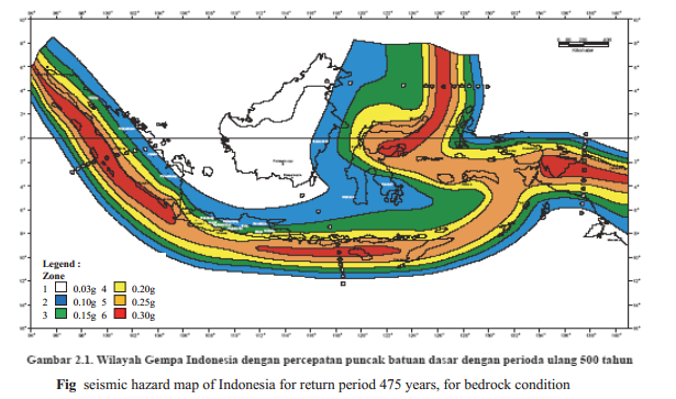
SEISMIC HAZARD ANALYSIS FOR SEISMIC DESIGN IN INDONESIA

-Dr. Rusnardi Rahamat Putra
Assistant Professor, Padang state University
Padang, Indonesia.

The Indonesian archipelago is located at the boundary of three major tectonic plates, the Indo-Australian, Pacific, and Eurasian plates, stretching from Sumatra in the west to Papua in the east. Indonesia is at the collision point of these three crustal plates. The high subduction-related seismicity in this region means that tsunami and other earthquake hazards are also high. Indonesia has approximately 17,504 islands, with a total land area of 1.92×10⁶   km2 and a sea area of 3.26×10⁶ km2. It has experienced a large number of earthquakes in the past. According to catalogued events, the number of earthquakes that have occurred in this region exceeds 45,778 with a magnitude greater than 4.0 from AD 1779 to 2010.
Most of the major historical earthquakes in Indonesia have caused significant damage to facilities (e.g., Utsu et al., 1992; Fauzi et al., 1999; EERI, 2010). Many large earthquakes have occurred in the shallow seas of the area that can produce massive tsunami like the 2004 Banda Aceh event. This earthquake off the coast of Sumatra resulted in hundreds of thousands of deaths and a million people homeless (Ghobarah. A et al., 2006). Tectonic and plate boundaries, Large arrows indicate the direction of plate motion.

Wednesday, September 11, 2013

भुकम्प, यसको असर र जोखीम


(भाद्र २६,२०७० को नागरिकमा प्रकाशित)

यहि भाद्र १४ गते रातको लगभग ११:३५ को आसपासमा नेपालको मध्यभाग ६ रिक्टर स्केल(स्थानिय मापन)को भुईचालोको कारण हल्लिन पुग्यो, सामाजिक संजालहरु एकै पटक भुकम्पमय बने, सबैजना यस प्रति चनाखो बनेको देखियो। UNDP को बिपद् ब्यबस्थापन संबन्धि संस्थाले २००४ मा निकालेको रिपोर्टको आधारमा बिश्वमा भुकम्पिय जोखिमको ११औं स्थानमा पर्ने देशमा हाम्रो तयारी कस्तो छ त? के हाम्रो समाजमा यस्ता भुकम्प आउदा के गर्नुपर्छ, कसरि सुरक्षित रहनुपर्छ भन्ने जनचेतना राम्रो छ त? हिजोकै केहि प्रतिक्रिया हरु हेर्दा र बुझ्दा यसको कमि देखिन्छ। पछिल्ला बर्षहरुमा भुकम्प आउने क्रम बढ्न थालेको देखिन्छ र यसले केहि बर्ष भित्रैमा ठुलै भुइचालो जान सक्छ भन्ने पनि बुझ्न सकिन्छ। भाग्यबस अहिले ठुलो भुईचालो आएको छैन, हामीले सानासाना भुइचालोहरु महसुस गरेका छौं, त्यसैले राजधानीमा ठुलो क्षति हुन पाएको छैन।
नेपालमा भुईचालोको ईतिहास करिब ई. सं. १२५५ देखिको रहेको पाईन्छ जुन समयमा काठमाण्डौंका एक तिहाई देखि एक चौथाई हाराहारी मानिसले ज्यान गुमाएको बताईन्छ। त्यस भन्दा पहिले पनि भुईचालो नगएका होईनन तर कुनै पनि यकिन समयका तथ्यहरु फेला नपरेका मात्र हुन।  यस्तै सन १४०८, १८१० मा पनि ठुला भुईचालो गएका थिए तर यसको यकिन तथ्यांक भेटिएको छैन। सन १८३३ देखि कुनै रुपमा तथ्यांकहरु पाउन सकिन्छ जुन समयमा ७.८ रिक्टरको भुइचालोका कारण काठमाण्डौंका करिब ५०० मानिसले ज्यान गुमाएका थिए। पछिल्लो सन १९३५ (बि. सं. १९९० माघ २) को भुईचालोलाई सबैभन्दा ठुलो भुइचालोको रुपमा लिईन्छ जसको कारण करिब १६००० मानिसको ज्यान गएको थियो। यसै महाभुकम्पको सम्झना र समाजमा भुकम्प संबन्धि जनचेतना फैलाउनको लागी त्यस दिनलाई प्रत्येक बर्ष भुकम्प दिबसको रुपमा मनाउन थालियो। यस बिचमा नेपाल वा भारतका बिभिन्न स्थानमा केन्द्रबिन्दु भएर गएका बिभिन्न भुकम्पको कारण पनि कयौं नेपालीले ज्यान गुमाइसकेका छन।
एक अनुसन्धानले हाम्रो देशको डिजाईन कोड (मापदण्ड) र प्रचलित निर्माण प्रबिधिले निर्मित संरचनाहरु अन्य मापदण्ड (ATC-40 FEMA-356) बाट निर्मित संरचना भन्दा बढि जोखिममा रहेको जनाएको छ। पछिल्लो समयमा बिभिन्न नगरपालिकाहरुले भुकम्पिय प्रतिरोधि भवनसंहिता लागु गरेकाले नक्सा बनाउदा अनिबार्य पर्ने ठाउँमा मात्र आम मानिसले घर बनाउदा नक्सा बनाउने गर्दछन तर यि मध्ये करिब ८५% (अनुमान) घर हरु नक्सामा रहेको संरचनागत डिजाईन नअपनाई, सामान्य निर्माण ठेकेदारको भरमा बन्ने गरेका छन। निकै कम मानिसले मात्र ईन्जिनियरको रेखदेखमा आफ्नो घर बनाउने गरेका छन। यस किसिमले निर्माण गरिएका संरचना कति बलियो होलान त? हामी सहजै अनुमान लगाउन सक्छौं।

Saturday, August 31, 2013

car crushed by landslide on 31st August 2013, Taiwan

You can see this video how landslide can crush the car... be safe.... be aware, every where...
This video is taken on Keelung-Badouzi, Taiwan
   

Saturday, August 10, 2013

Earthquake alert message in Japan went wrong

August 08, 2013 at 4:56 PM, i was in my research laboratory concentrating on some programs of my research, In laboratory there are also other friends who are busy on their own task, Cell phones of one friend start to ring and vibrate on different sound, then all of us just little bit confuse about that sound but later with in seconds all of our cell phones display emergency message about the great earthquak . All of us took precautions and just hide under the table but up to few minutes we did not feel any tremor then we just came to normal schedule.

This is the message received on my cell phone

Japan had the best system to issue the emergency warnings (you can see here about earthquake warning system in Japan ) on such events so everyone cares about such message. Messages are not only displayed on mobiles but they automatically broadcast from televisions also. After this message all the train lines got emergency stops, several factories went to just stuck, Hospitals, schools, public areas all got alert. People scared and and remembered one devastating great east Japan earthquake 2011 march. 

Sunday, August 4, 2013

प्रकोप न्युनिकरण र बिकासका चुनौती


 - ई. केशब शर्मा (पौडेल)

मनसुनको औपचारिक प्रबेश नहुँदै जेष्ठ २२ गते राती ताप्लेजुङ्गको थुकिम्बा मा गएको पहिरोले एकै परिवारका सात जनाको मृत्यु तथा चार जना बेपत्ता भएको खबर आयो त्यस पछी भोजपुर हुँदै मध्य तथा सुदुरपश्चिम लगायत देशका धेरै स्थानहरुमा भीषण वर्षा सँगै आएको बाढी पहिरोले धेरै जनधनको क्षती भएको सरकारी तथ्यांक अनुसार यसै वर्षको असारसम्म मात्र बाढी पहिरोले  ६० जना भन्दा बढीले ज्यान गुमाइसकेका करीब बाह्र हजार जना बिस्थापित भइसकेका छन  बाढीपहिरोको कारणले नेपालमा हरेक वर्षमा २०० जना भन्दा बढीको मृत्यु, ३०००४००० घरहरु ध्वस्त तथा दशौं हजार मानीसहरु प्रभाबित अरबौंको क्षती हुने देखीन्छ
नेपालको करिब ८३. % भुभाग पहाडी तथा हिमाली क्षेत्रले ओगटेको छ। नेपालको भु-बनोट विश्वमै कान्छो, अत्यन्त कमजोर उतारचढाब युक्त मानिन्छ जुन पहिरोको लागि सहज हुन्छ नेपालका पहाडहरु अत्यन्त भिराला, अग्ला नरम छन, जब महिनामै  २५०० मिलिमीटर पानी पर्छ भने त्यसलाई पहाडले थेग्न सक्दैन पैहृो जान्छ नदीले समेट्न सक्दैन बाढी आउँछ केही वर्ष यता धेरै स्थानमा सुख्खा पहिरो पनि जान थालेको

Monday, July 29, 2013

1980 M6.6 Earthquake of Western Nepal.


Today July 29, in 1980 western Nepal faced the tremor of M6.6 which took away about 150 lives and left injured nearly 1000 people. Estimated economic loss of that earthquake was ($245 milion!). Nepalese media and people may forget it but they have to remember those events and prepare for next event like this or even more devastating one in near future. Here is a short view on history of earthquake.
Location of 1980 earthquake

Nepal lies on seismic zone, it rests on the boundary of eurasian plate and indian plate with major faults parallel to its length. There are many fault activities responsible for ground tremors, some of them claim casualties but most of them are weak in their power. Nepal has the history of earthquake from 1255 AD when it was assumed that, 1/3 to 1/4th population got death due to earthquake about X in MM scale in Kathmandu, capital of Nepal.

Sunday, July 28, 2013

About Seismic Design Code in Nepal

(This is the part of paper that published on NEA 13th Convention technical journal in Kathmandu.)

ABSTRACT: This paper focus on study of worldwide changes in seismic design codes after large earthquakes especially in design ground motion. Kathmandu is moving towards one of mega cities in Asia, so for urban development in future we have to consider all perspectives of design methodologies to have resilient city not only Kathmandu but also all other major cities. High rise buildings and major lifeline structures within city and gateway to cities are very important to be safe. Design methodologies are major factors of control for the disaster resilient structures alongside with regulation during construction. Here we discuss about consideration of phase for design ground motion for safer structural design. 


Key Words: Urban development, seismic design, phase spectra, design ground motion

INTRODUCTION